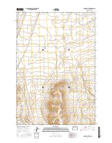
2017 Map of Service Buttes
USGS Topo · Published 2017About this map
Service Buttes anchor the southern landscape of this Umatilla County quadrangle, rising above a network of canyons and springs that have sustained travelers for generations. Modern infrastructure traces the path of history along Oregon Trail Rd, which cuts across the central township through Service Canyon. The northern portion of the map transitions into the irrigated agricultural lands of Echo Meadows, supported by Hunt Ditch and the drainage of Butter Cr. Water remains a critical element of this high-desert environment, evidenced by isolated reliable sources like Service Springs and Vey Spring. A grid of county roads, including Eagle Ranch Rd and Garden Creek Rd, provides access to ranching lands and the varied topography of Spikes Gulch, illustrating the intersection of historic transit corridors and contemporary land management.
Find a feature on this map
22 named features on this map. Tap any name to fly to it.
Don’t see what you’re looking for? This feature index may not catch every label — zoom into the map to look around manually.
Map Details
Editions of this 2017 Service Buttes Map
This is the sole edition of this map. No revisions or reprints were ever made.
Other maps of this area

1908 · Umatilla
USGS Topo · 1:125,000

1953 · Pendleton
USGS Topo · 1:250,000

1956 · Pendleton
USGS Topo · 1:250,000

1962 · Stanfield
USGS Topo · 1:24,000

1962 · Ordnance
USGS Topo · 1:24,000

1962 · Hermiston
USGS Topo · 1:24,000

1968 · Service Buttes NW
USGS Topo · 1:24,000
1968 · Echo
USGS Topo · 1:24,000

1968 · Vey Ranch
USGS Topo · 1:24,000

1968 · Butter Creek Junction
USGS Topo · 1:24,000