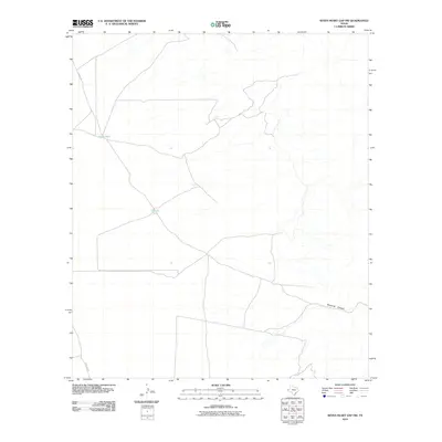
2010 Map of Seven Heart Gap NW
USGS Topo · Published 2010About this map
Johns Well and Ocotillo Tank serve as critical water markers in this arid section of Culberson County, where the landscape is defined by sparse drainage and isolation. The map illustrates a network of desert tracks including Stone Rd and Two Flat Rd, which provide the primary means of traversal across this high-desert terrain. In the southeastern portion, the contours of Maverick Canyon break the relatively open topography. This 2010 digital survey by the U.S. Geological Survey captures the region's essential hydrological and transportation infrastructure, which has remained largely unchanged for decades due to the environment's remote nature. Researchers can observe how limited water sources dictated the placement of ranching infrastructure and local roads.
Find a feature on this map
5 named features on this map. Tap any name to fly to it.
Don’t see what you’re looking for? This feature index may not catch every label — zoom into the map to look around manually.
Map Details
Editions of this 2010 Seven Heart Gap NW Map
This is the sole edition of this map. No revisions or reprints were ever made.
Other maps of this area

1906 · Van Horn
USGS Topo · 1:125,000

1954 · Van Horn
USGS Topo · 1:250,000

1958 · Van Horn
USGS Topo · 1:250,000

1972 · Seven Heart Gap
USGS Topo · 1:24,000

1972 · Square Mesa
USGS Topo · 1:24,000
1973 · Victorio Peak
USGS Topo · 1:24,000

1973 · Bitter Well Mountain
USGS Topo · 1:24,000
1973 · Delaware Ranch
USGS Topo · 1:24,000

1973 · Burro Canyon
USGS Topo · 1:24,000
1973 · Seven Heart Gap NW
USGS Topo · 1:24,000