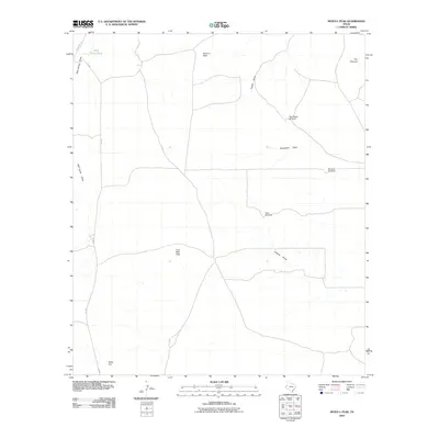
2010 Map of Seven L Peak
USGS Topo · Published 2010About this map
Seven L Peak and other high desert formations define this West Texas landscape, where life and transit are dictated by the presence of water and seasonal drainages. The area is characterized by a network of intermittent watercourses including Wild Horse Draw, Castile Draw, and Virginia Draw, which carve through the arid terrain. Human infrastructure is Sparse, focused primarily on livestock management as evidenced by the distribution of water-gathering sites like Wild Horse Tank and functional landmarks such as West Rader Windmill and Division Windmill. The map reveals a land of significant elevation changes, from the plateau of Table Top to the distinct prominence of The Pinnacle. Transportation is limited to a few secondary routes, primarily University Rd and KC Rd, which provide the only developed access through this remote portion of Culberson County.
Find a feature on this map
14 named features on this map. Tap any name to fly to it.
Don’t see what you’re looking for? This feature index may not catch every label — zoom into the map to look around manually.
Map Details
Editions of this 2010 Seven L Peak Map
This is the sole edition of this map. No revisions or reprints were ever made.
Other maps of this area

1954 · Van Horn
USGS Topo · 1:250,000

1958 · Van Horn
USGS Topo · 1:250,000

1973 · Seven L Peak
USGS Topo · 1:24,000

1973 · Two Mill Draw West
USGS Topo · 1:24,000

1973 · Seven L Peak NE
USGS Topo · 1:24,000

1973 · K C Ranch
USGS Topo · 1:24,000

1973 · Chico Draw East
USGS Topo · 1:24,000

1973 · Cow Mountain
USGS Topo · 1:24,000

1973 · Delaware Spring
USGS Topo · 1:24,000
1973 · Emory Corral
USGS Topo · 1:24,000