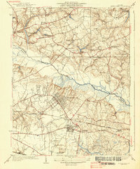
1938 Map of Seven Pines
USGS Topo · Published 1938About this map
Chickahominy River carves through the center of this landscape, marking the boundary between Hanover Co and Henrico Co in the mid-1930s. The map illustrates a region heavy with history, preserved along the Battlefield Park Route and sites like Gaines Mill, Old Cold Harbor, and the National Cem. To the south, the impact of early aviation is clear at the Richard E Byrd Landing Field, supported by a Radio Range Beacon. Residential and industrial growth is centered around Highland Springs and Sandston, where the street grids are densely mapped. Local commerce and transit are anchored by the Southern and C and O railroads, connecting rural outposts like Savage Sta and Manbur to the broader Virginia network. Numerous country schools and churches, including Rock Hill Sch and Beulah Ch, reveal the community structure of the era.
Find a feature on this map
49 named features on this map. Tap any name to fly to it.
Don’t see what you’re looking for? This feature index may not catch every label — zoom into the map to look around manually.
Map Details
Editions of this 1938 Seven Pines Map
3 editions found
Other maps of this area

1894 · Bermuda Hundred
USGS Topo · 1:62,500

1894 · Richmond
USGS Topo · 1:62,500

1895 · Richmond
USGS Topo · 1:62,500

1918 · Charles City
USGS Topo · 1:62,500

1920 · King William
USGS Topo · 1:62,500

1934 · Seven Pines
USGS Topo · 1:24,000

1934 · Richmond
USGS Topo · 1:24,000

1938 · Dutch Gap
USGS Topo · 1:24,000

1938 · Seven Pines
USGS Topo · 1:31,680

1938 · Drewrys Bluff
USGS Topo · 1:24,000