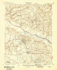
1938 Map of Seven Pines
USGS Topo · Published 1946About this map
Seven Pines and the surrounding Henrico County countryside appear here in the mid-1930s, showing a landscape defined by significant infrastructure and deep historical memory. The Chickahominy River bisects the area, its swampy reaches such as Whiteoak Swamp and Elder Swamp bordering the growing residential grid of Highland Springs and Sandston. Transportation is central to this era, with the Southern Railway cutting through Manbur and the Richard E Byrd Landing Field established to the south.
Find a feature on this map
52 named features on this map. Tap any name to fly to it.
Don’t see what you’re looking for? This feature index may not catch every label — zoom into the map to look around manually.
Map Details
Editions of this 1938 Seven Pines Map
3 editions found
Other maps of this area

1894 · Bermuda Hundred
USGS Topo · 1:62,500

1894 · Richmond
USGS Topo · 1:62,500

1895 · Richmond
USGS Topo · 1:62,500

1918 · Charles City
USGS Topo · 1:62,500

1920 · King William
USGS Topo · 1:62,500

1934 · Seven Pines
USGS Topo · 1:24,000

1934 · Richmond
USGS Topo · 1:24,000

1938 · Dutch Gap
USGS Topo · 1:24,000

1938 · Seven Pines
USGS Topo · 1:31,680

1938 · Drewrys Bluff
USGS Topo · 1:24,000