
1970 Map of Sevenmile Corner
USGS Topo · Published 1973About this map
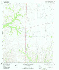
The settlement ruins of Upland sit in the northwest corner of this West Texas landscape, a testament to the shifting fortunes of Upton County ranching and early petroleum interests. Captured in the early 1970s, the map reveals a transition from traditional livestock raising to intensive industrial exploration. The terrain is defined by the winding course of China Draw and the presence of numerous family-named landmarks like Tippet Ranch and the Joe Bailey Windmill. These features, alongside the Duke Hill Windmill, reflect the critical importance of water access in an arid environment. The map also documents the proliferation of energy infrastructure at Sevenmile Corner, where countless drill holes and oil wells dot the landscape. This intersection of historic ranching life and modern resource extraction is punctuated by smaller industrial sites such as a Gravel Pit, providing a detailed look at the rural economy of the Permian Basin era.
Find a feature on this map
8 named features on this map. Tap any name to fly to it.
Don’t see what you’re looking for? This feature index may not catch every label — zoom into the map to look around manually.
Map Details
Editions of this 1970 Sevenmile Corner Map
2 editions found
Other maps of this area

1928 · Crane
USGS Topo · 1:125,000

1928 · Rankin
USGS Topo · 1:125,000

1954 · Pecos
USGS Topo · 1:250,000

1954 · San Angelo
USGS Topo · 1:250,000

1957 · Pecos
USGS Topo · 1:250,000

1958 · San Angelo
USGS Topo · 1:250,000

1965 · San Angelo
USGS Topo · 1:250,000

1970 · Sevenmile Corner NE
USGS Topo · 1:24,000

1970 · Lindsey Ranch
USGS Topo · 1:24,000

1970 · Sevenmile Corner SE
USGS Topo · 1:24,000