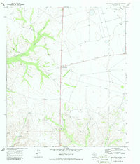
1970 Map of Sevenmile Corner
USGS Topo · Published 1987About this map
The arid landscape of Upton County is characterized here by its emerging industrial and ranching infrastructure as it appeared in the late 1960s and early 1970s. The terrain is centered on Sevenmile Corner, where a network of subterranean Pipelines and numerous Drill Holes indicate active energy exploration across the West Texas plains. Water sources are critical to the few established outposts in this environment, evidenced by the Joe Badey Windmill and the Duke Hill Windmill situated near the drainage of China Draw. While the high ground is marked by these industrial survey points, the lower elevations show the occasional Gravel Pit and the remote Tippet Ranch, providing a window into the land use of a region defined by its oil-and-cattle economy.
Find a feature on this map
11 named features on this map. Tap any name to fly to it.
Don’t see what you’re looking for? This feature index may not catch every label — zoom into the map to look around manually.
Map Details
Editions of this 1970 Sevenmile Corner Map
2 editions found

Other maps of this area

1928 · Crane
USGS Topo · 1:125,000

1928 · Rankin
USGS Topo · 1:125,000

1954 · Pecos
USGS Topo · 1:250,000

1954 · San Angelo
USGS Topo · 1:250,000

1957 · Pecos
USGS Topo · 1:250,000

1958 · San Angelo
USGS Topo · 1:250,000

1965 · San Angelo
USGS Topo · 1:250,000

1970 · Sevenmile Corner NE
USGS Topo · 1:24,000

1970 · Lindsey Ranch
USGS Topo · 1:24,000

1970 · Sevenmile Corner SE
USGS Topo · 1:24,000