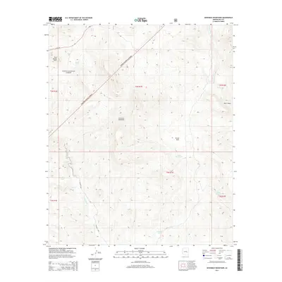
2014 Map of Sevenmile Mountains
USGS Topo · Published 2014About this map
Sevenmile Mountains dominate this central Arizona landscape, located within the protected boundaries of the Tonto National Forest. The 2014 survey documents a rugged high-desert environment where water sources are critical for land use and navigation. Water features such as Sevenmile Tank, Poverty Spring, Gerald Spring, and Wood Spring are vital markers for those tracing the history of local ranching or backcountry movement. The terrain is further defined by prominent landmarks like Rock Springs Butte and Brushy Basin, with Sevenmile Wash and Corral Cr providing natural drainage corridors through the forest. The presence of US Hwy 60 in the northwest corner indicates the primary modern transport artery, contrasting with the remote canyons like Bear Canyon and basins that characterize the interior of the quadrangle.
Find a feature on this map
21 named features on this map. Tap any name to fly to it.
Don’t see what you’re looking for? This feature index may not catch every label — zoom into the map to look around manually.
Map Details
Editions of this 2014 Sevenmile Mountains Map
This is the sole edition of this map. No revisions or reprints were ever made.
Other maps of this area

1922 · Chrysotile
USGS Topo · 1:125,000

1954 · Mesa
USGS Topo · 1:250,000

1957 · Mesa
USGS Topo · 1:250,000

1958 · Mesa
USGS Topo · 1:250,000

1960 · Mesa
USGS Topo · 1:250,000

1964 · Mesa
USGS Topo · 1:250,000

1966 · Brushy Canyon
USGS Topo · 1:24,000

1966 · Natural Corral
USGS Topo · 1:24,000
1966 · Dourine Canyon
USGS Topo · 1:24,000

1966 · Cassadore Spring
USGS Topo · 1:24,000