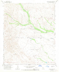
1966 Map of Dourine Canyon
USGS Topo · Published 1967About this map
The San Carlos Indian Reservation landscape is defined by an intricate network of drainage systems and isolated water sources used for ranching and mining. In the mid-1960s, the Circle Seven Ranch serves as a primary point of human activity within this environment, situated near the intersection of Sevenmile Wash and Champion Creek. The terrain is marked by significant features like Dourine Canyon and Quail Mesa, while the presence of the Metate Mine and various named tanks such as Metate Tank and Steer Tank points to a specialized land use focused on resource extraction and livestock management. Numerous jeep trails crisscross the area, connecting remote locations like Chatto Well and Bisto Well, illustrating the logistical challenges and rural character of Gila County during this era.
Find a feature on this map
24 named features on this map. Tap any name to fly to it.
Don’t see what you’re looking for? This feature index may not catch every label — zoom into the map to look around manually.
Map Details
Editions of this 1966 Dourine Canyon Map
2 editions found
Other maps of this area

1922 · Chrysotile
USGS Topo · 1:125,000

1954 · Mesa
USGS Topo · 1:250,000

1957 · Mesa
USGS Topo · 1:250,000

1958 · Mesa
USGS Topo · 1:250,000

1960 · Mesa
USGS Topo · 1:250,000

1964 · Mesa
USGS Topo · 1:250,000

1965 · Bucket Mtn
USGS Topo · 1:24,000

1966 · Natural Corral
USGS Topo · 1:24,000

1966 · Cassadore Spring
USGS Topo · 1:24,000
1966 · Sevenmile Mts.
USGS Topo · 1:24,000