
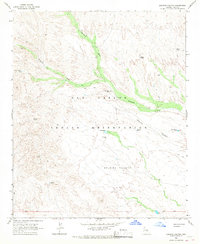
1965 Map of Bucket Mtn
USGS Topo · Published 1968About this map
The San Carlos Indian Reservation landscape is defined by the ephemeral Gilson Wash and the infrastructure required for cattle ranching in a dry climate. In the mid-1960s, the Southern Pacific railroad and a major Pipeline cut across the northern portion of the quadrangle, serving as vital industrial conduits through the desert terrain. Significant landmarks include the San Carlos Job Corps Conservation Center and several reliable water sources such as Dripping Springs and Gilson Well.
Find a feature on this map
27 named features on this map. Tap any name to fly to it.
Don’t see what you’re looking for? This feature index may not catch every label — zoom into the map to look around manually.
Map Details
Editions of this 1965 Bucket Mtn Map
This is the sole edition of this map. No revisions or reprints were ever made.
Other maps of this area

1915 · Christmas
USGS Topo · 1:62,500

1917 · Christmas
USGS Topo · 1:62,500

1954 · Mesa
USGS Topo · 1:250,000

1957 · Mesa
USGS Topo · 1:250,000

1958 · Mesa
USGS Topo · 1:250,000

1960 · Mesa
USGS Topo · 1:250,000

1962 · San Carlos Reservoir
USGS Topo · 1:62,500

1964 · Mesa
USGS Topo · 1:250,000

1966 · Natural Corral
USGS Topo · 1:24,000
1966 · Dourine Canyon
USGS Topo · 1:24,000