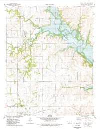
1975 Map of Severy North
USGS Topo · Published 1978About this map
The Fall River Lake reservoir dominates this portion of Greenwood County, where the Fall River was impounded to create the State Wildlife Management Area. The landscape in the mid-1970s shows a complex network of tributaries including Otter Creek, Snake Creek, and Casner Creek feeding into the larger water system. Human settlement is centered on the small communities of Climax and Severy, with the latter positioned near the southern boundary where the St Louis San Francisco railroad cuts across the prairie. Evidence of local industry and infrastructure is visible through scattered Oil Wells, an Oil Field, and the Atchison Topeka and Santa Fe rail line running north-south through the terrain. Genealogists will find the Twin Grove Cem and South Lawn Cem useful for locating family records in Twin Grove.
Find a feature on this map
25 named features on this map. Tap any name to fly to it.
Don’t see what you’re looking for? This feature index may not catch every label — zoom into the map to look around manually.
Map Details
Editions of this 1975 Severy North Map
This is the sole edition of this map. No revisions or reprints were ever made.
Other maps of this area

1885 · Eureka
USGS Topo · 1:125,000

1888 · Eureka
USGS Topo · 1:125,000

1894 · Eureka
USGS Topo · 1:125,000

1939 · Severy
USGS Topo · 1:62,500

1941 · Severy
USGS Topo · 1:62,500

1955 · Wichita
USGS Topo · 1:250,000

1958 · Wichita
USGS Topo · 1:250,000
1964 · Piedmont NE
USGS Topo · 1:24,000
1964 · Piedmont
USGS Topo · 1:24,000
1969 · Neal
USGS Topo · 1:24,000