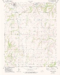
1975 Map of Severy South
USGS Topo · Published 1978About this map
The railroad junction at Severy anchors this mid-1970s survey, where the St Louis-San Francisco and Atchison Topeka and Santa Fe lines cross near the Greenwood and Elk County line. The landscape is a mix of agricultural pasture and energy extraction, evidenced by scattered Oil Wells and a Quarry in the township of Win Grove. To the north, the Severy Municipal Reservoir serves as a local water source, while the southern reaches near the small settlement of Fiat are defined by the winding paths of Indian Creek and Snake Creek. Local community life is marked by landmarks like the Sunflower Grange Hall and the Pleasant View Cemetery, showing the rural social structure during this period of Kansas history. The map also records specialized infrastructure, such as the Gaging Station on Snake Creek and Sewage Disposal Ponds near the town center.
Find a feature on this map
22 named features on this map. Tap any name to fly to it.
Don’t see what you’re looking for? This feature index may not catch every label — zoom into the map to look around manually.
Map Details
Editions of this 1975 Severy South Map
This is the sole edition of this map. No revisions or reprints were ever made.
Other maps of this area

1885 · Eureka
USGS Topo · 1:125,000

1885 · Sedan
USGS Topo · 1:125,000

1888 · Eureka
USGS Topo · 1:125,000

1889 · Sedan
USGS Topo · 1:125,000

1894 · Eureka
USGS Topo · 1:125,000

1939 · Severy
USGS Topo · 1:62,500

1941 · Severy
USGS Topo · 1:62,500

1955 · Wichita
USGS Topo · 1:250,000

1958 · Wichita
USGS Topo · 1:250,000
1964 · Longton
USGS Topo · 1:24,000