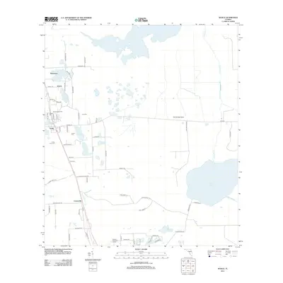
2012 Map of Seville
USGS Topo · Published 2012About this map
Seville and its surrounding citrus and fern-growing landscapes define this portion of Volusia County, where the settlement pattern is deeply tied to the local hydrology. The map reveals a dense network of family-named landmarks and burial grounds, such as the Causey Family Cemetery and Roberts Cemetery, which provide critical points of reference for genealogists. The terrain is dominated by a complex system of cypress heads and wetlands, notably Lake Disston and the sprawling Haw Creek Preserve to the east. Transportation routes like Turkey Shoot Road and Little Brown Church Road branch off from the main north-south corridors, connecting smaller communities like Bakerstown and Senyah. The presence of the Seville Lookout Tower and the Pierson Municipal Airport further south illustrates the mix of agricultural monitoring and regional aviation infrastructure in this corner of Florida.
Find a feature on this map
70 named features on this map. Tap any name to fly to it.
Don’t see what you’re looking for? This feature index may not catch every label — zoom into the map to look around manually.
Map Details
Editions of this 2012 Seville Map
This is the sole edition of this map. No revisions or reprints were ever made.
Other maps of this area

1954 · Daytona Beach
USGS Topo · 1:250,000

1958 · Daytona Beach
USGS Topo · 1:250,000

1964 · Daytona Beach
USGS Topo · 1:250,000

1970 · Crescent City
USGS Topo · 1:24,000

1970 · Welaka SE
USGS Topo · 1:24,000

1970 · Seville
USGS Topo · 1:24,000
1970 · Bunnell
USGS Topo · 1:24,000

1970 · Pierson
USGS Topo · 1:24,000
1971 · Lake Dias
USGS Topo · 1:24,000
1972 · St. Johns Park
USGS Topo · 1:24,000