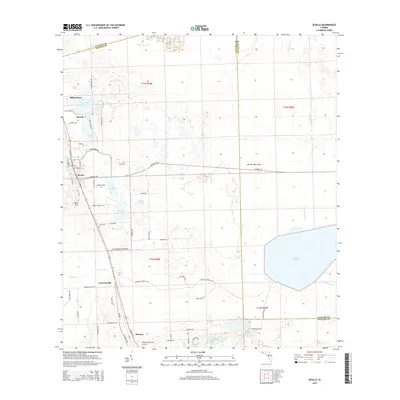
2015 Map of Seville
USGS Topo · Published 2015About this map
The agricultural corridor of the Florida interior is captured here along the intersection of Volusia, Putnam, and Flagler counties. Seville and Pierson anchor a landscape defined by fernery roads and timber trails, where small settlements like Senyah, Bakerstown, and Connersville mark the local topography. This region is dotted with numerous cypress-rimmed depressions and named water bodies including Lake Disston, Hokey Lake, and Cow Pond. Genealogy researchers will find significant value in the concentration of family-named burial grounds, such as the Causey Family Cem, Roberts Cem, and Harris Cem. The landscape transitions from the developed grids around the Pierson Municipal Airport to the more untamed terrain of Salt Springs Island and the expansive wetlands surrounding Price Creek. The network of roads like Cade Fernery Rd and Ninemile Point Rd reflects the local industry and settlement patterns of this central Florida region.
Find a feature on this map
69 named features on this map. Tap any name to fly to it.
Don’t see what you’re looking for? This feature index may not catch every label — zoom into the map to look around manually.
Map Details
Editions of this 2015 Seville Map
This is the sole edition of this map. No revisions or reprints were ever made.
Other maps of this area

1954 · Daytona Beach
USGS Topo · 1:250,000

1958 · Daytona Beach
USGS Topo · 1:250,000

1964 · Daytona Beach
USGS Topo · 1:250,000

1970 · Crescent City
USGS Topo · 1:24,000

1970 · Welaka SE
USGS Topo · 1:24,000

1970 · Seville
USGS Topo · 1:24,000
1970 · Bunnell
USGS Topo · 1:24,000

1970 · Pierson
USGS Topo · 1:24,000
1971 · Lake Dias
USGS Topo · 1:24,000
1972 · St. Johns Park
USGS Topo · 1:24,000