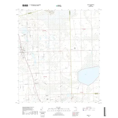
2018 Map of Seville
USGS Topo · Published 2018About this map
Seville and Pierson anchor this Florida landscape, where the agricultural and rail history of Volusia County remains clearly visible. The region is defined by a dense network of water bodies and marshlands, notably Lake Disston and Little Haw Cr, which weave through the eastern sections. For genealogists and local historians, the area is rich with family-named landmarks and several distinct burial sites, including the Seville Cem, Causey Family Cem, and Harris Cem. The transportation infrastructure is well-established, featuring the CSX Transportation railroad corridor and the Pierson Municipal Airport. Smaller settlements like Connersville and Senyah appear alongside numerous rural routes such as Little Brown Church Rd and Ninemile Point Rd, reflecting the long-standing community patterns of this fern-growing heartland.
Find a feature on this map
75 named features on this map. Tap any name to fly to it.
Don’t see what you’re looking for? This feature index may not catch every label — zoom into the map to look around manually.
Map Details
Editions of this 2018 Seville Map
This is the sole edition of this map. No revisions or reprints were ever made.
Other maps of this area

1954 · Daytona Beach
USGS Topo · 1:250,000

1958 · Daytona Beach
USGS Topo · 1:250,000

1964 · Daytona Beach
USGS Topo · 1:250,000

1970 · Crescent City
USGS Topo · 1:24,000

1970 · Welaka SE
USGS Topo · 1:24,000

1970 · Seville
USGS Topo · 1:24,000
1970 · Bunnell
USGS Topo · 1:24,000

1970 · Pierson
USGS Topo · 1:24,000
1971 · Lake Dias
USGS Topo · 1:24,000
1972 · St. Johns Park
USGS Topo · 1:24,000