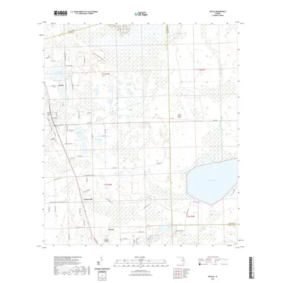
2021 Map of Seville
USGS Topo · Published 2021About this map
Pierson serves as the primary hub of this interior Florida landscape, situated within a patchwork of fernery roads and conservation lands. The area is defined by its extensive wetlands and numerous water bodies, most notably Lake Disston and Hokey Lake. The map reveals a high concentration of family and local burial sites, including Seville Cem, Cone Cem, Roberts Cem, Causey Family Cem, and Harris Cem, which offer significant value for genealogical research. Small settlements like Senyah and Connersville anchor the surrounding rural expanse, while the Pierson Municipal Airport and a network of named trails like the Crescent Lake Conservation Area Trl indicate a mix of transport and recreation. The terrain is characterized by features such as Salt Springs Island and Saw Grass Bay, reflecting the low-lying, water-dominant environment at the intersection of Volusia, Putnam, and Flagler counties.
Find a feature on this map
70 named features on this map. Tap any name to fly to it.
Don’t see what you’re looking for? This feature index may not catch every label — zoom into the map to look around manually.
Map Details
Editions of this 2021 Seville Map
This is the sole edition of this map. No revisions or reprints were ever made.
Other maps of this area

1954 · Daytona Beach
USGS Topo · 1:250,000

1958 · Daytona Beach
USGS Topo · 1:250,000

1964 · Daytona Beach
USGS Topo · 1:250,000

1970 · Crescent City
USGS Topo · 1:24,000

1970 · Welaka SE
USGS Topo · 1:24,000

1970 · Seville
USGS Topo · 1:24,000
1970 · Bunnell
USGS Topo · 1:24,000

1970 · Pierson
USGS Topo · 1:24,000
1971 · Lake Dias
USGS Topo · 1:24,000
1972 · St. Johns Park
USGS Topo · 1:24,000