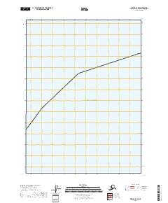
2018 Map of Seward A-1 SE
USGS Topo · Published 2018About this map
Gulf of Alaska waters dominate this coastal survey of the southern Alaska coastline, documenting a remote maritime environment where the open ocean meets the rugged littoral zone. The map primarily depicts the marine expanse, intersected by the township boundary for T1s R13e along the shoreline. Unlike many topographic sheets characterized by dense inland settlement, this document focuses on the precise coastal boundary and the section lines that define the legal landscape of the Kenai Peninsula region. It provides a clear record of the shoreline's position in the early twenty-first century, serving as a baseline for understanding the physical geography of this secluded stretch of the Alaskan coast.
Find a feature on this map
20 named features on this map. Tap any name to fly to it.
Don’t see what you’re looking for? This feature index may not catch every label — zoom into the map to look around manually.
Map Details
Editions of this 2018 Seward A-1 SE Map
This is the sole edition of this map. No revisions or reprints were ever made.
Other maps of this area

1946 · Blying Sound
USGS Topo · 1:250,000

1948 · Cordova
USGS Topo · 1:250,000

1948 · Middleton Island
USGS Topo · 1:250,000

1950 · Middleton Island
USGS Topo · 1:250,000

1951 · Blying Sound
USGS Topo · 1:250,000

1951 · Seward
USGS Topo · 1:250,000

1951 · Cordova
USGS Topo · 1:250,000

1951 · Seward A-1
USGS Topo · 1:63,360
1951 · Cordova A-7 and A-8
USGS Topo · 1:63,360

1953 · Seward A-1
USGS Topo · 1:63,360