
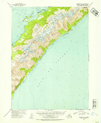
1953 Map of Seward A-1
USGS Topo · Published 1954About this map
Montague Island, at the northern entrance to Prince William Sound, dominates this 1953 survey. The landscape is defined by the steep elevation of Montague Peak and the dramatic shoreline of Purple Bluff, which drops sharply toward the Gulf of Alaska. On the island's northwestern shore, the protected waters of Port Chalmers and the nearby Wilby Island provide a break in the exposed coastline. This area, situated within the Chugach National Forest, shows very little human footprint during this era, with only isolated cabins appearing on the western coast. The map provides precise soundings along the shelf, reflecting the primary importance of maritime navigation for this part of the Alaska-Third Judicial Division before the 1964 earthquake significantly altered these coastal elevations.
Find a feature on this map
8 named features on this map. Tap any name to fly to it.
Don’t see what you’re looking for? This feature index may not catch every label — zoom into the map to look around manually.
Map Details
Editions of this 1953 Seward A-1 Map
2 editions found
Other maps of this area

1946 · Blying Sound
USGS Topo · 1:250,000

1948 · Cordova
USGS Topo · 1:250,000

1948 · Middleton Island
USGS Topo · 1:250,000

1950 · Middleton Island
USGS Topo · 1:250,000

1951 · Blying Sound
USGS Topo · 1:250,000

1951 · Seward
USGS Topo · 1:250,000

1951 · Cordova
USGS Topo · 1:250,000

1951 · Seward B-1
USGS Topo · 1:63,360

1951 · Seward A-2
USGS Topo · 1:63,360

1951 · Blying Sound D-1 and D-2
USGS Topo · 1:63,360