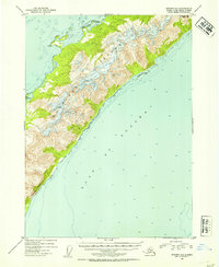
1953 Map of Seward A-1
USGS Topo · Published 1954About this map
Montague Island dominates this mid-century survey, its steep ridges and coastal indentations rising directly from the Gulf of Alaska. Entirely contained within the Chugach National Forest, the landscape is defined by its isolation and maritime geography. The northern reaches of the island include Port Chalmers and Wilby Island, where the terrain creates a natural anchorage sheltered from the open gulf. Small indications of human presence appear only at the shoreline, such as the Cabins marked on the western coast.
Find a feature on this map
8 named features on this map. Tap any name to fly to it.
Don’t see what you’re looking for? This feature index may not catch every label — zoom into the map to look around manually.
Map Details
Editions of this 1953 Seward A-1 Map
2 editions found

Other maps of this area

1946 · Blying Sound
USGS Topo · 1:250,000

1948 · Cordova
USGS Topo · 1:250,000

1948 · Middleton Island
USGS Topo · 1:250,000

1950 · Middleton Island
USGS Topo · 1:250,000

1951 · Blying Sound
USGS Topo · 1:250,000

1951 · Seward
USGS Topo · 1:250,000

1951 · Cordova
USGS Topo · 1:250,000

1951 · Seward B-1
USGS Topo · 1:63,360

1951 · Seward A-2
USGS Topo · 1:63,360

1951 · Blying Sound D-1 and D-2
USGS Topo · 1:63,360