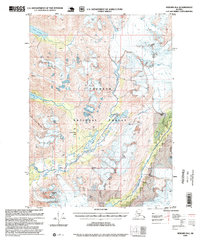
1995 Map of Seward B-6
USGS Topo · Published 1999About this map
Chugach National Forest land dominates this high-altitude landscape of the Kenai Peninsula, where the retreat of massive ice fields is the primary driver of the terrain. The presence of the Mother Goose Glacier, Seward Glacier, and Wolverine Glacier alongside the newer Ellsworth Glacier illustrates a dynamic glacial environment at the end of the twentieth century. Human activity is sparse but notable, marked by isolated structures like the Lower Paradise Lake Cabin (FS) and Upper Paradise Lake Cabin (FS) within the Paradise Valley. Evidence of earlier resource exploration persists in the form of unnamed Prospects located near Falls Creek, while the Snow River and its associated Snow River Pass suggest the traditional corridors used to navigate this mountainous interior. The presence of a Gaging Station and various Cabins further indicates the ongoing scientific and recreational management of these protected lands.
Find a feature on this map
28 named features on this map. Tap any name to fly to it.
Don’t see what you’re looking for? This feature index may not catch every label — zoom into the map to look around manually.
Map Details
Editions of this 1995 Seward B-6 Map
This is the sole edition of this map. No revisions or reprints were ever made.
Other maps of this area

1950 · Seward A-6
USGS Topo · 1:63,360

1950 · Seward A-7
USGS Topo · 1:63,360

1951 · Seward
USGS Topo · 1:250,000

1951 · Seward A-6
USGS Topo · 1:63,360

1951 · Seward A-7
USGS Topo · 1:63,360

1951 · Seward B-7
USGS Topo · 1:63,360

1951 · Seward C-6
USGS Topo · 1:63,360

1951 · Seward C-5
USGS Topo · 1:63,360

1951 · Seward A-5
USGS Topo · 1:63,360

1951 · Seward B-6
USGS Topo · 1:63,360