
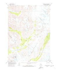
1951 Map of Seward B-6
USGS Topo · Published 1965About this map
Andy Simons Mountain and the towering ice of the Mother Goose Glacier define this mid-century survey of the Kenai Peninsula wilderness. This landscape within the Chugach National Forest is characterized by its dynamic glacial features, including numerous crevasses and the massive reach of the Ellsworth Glacier at its southeastern edge. The map captures the natural drainage patterns of the era, where the Snow River and Nellie Juan River cut through the high terrain. The presence of the Ptarmigan Lake Trail and Paradise Valley Trail indicates the established routes used by hunters and early outdoorsmen to navigate between Ptarmigan Lake and the interconnected waters of Upper Paradise Lake and Lower Paradise Lake. These trails and the narrow Snow River Pass represent the primary human imprints on a region otherwise dominated by ice fields and seasonal snowmelt.
Find a feature on this map
19 named features on this map. Tap any name to fly to it.
Don’t see what you’re looking for? This feature index may not catch every label — zoom into the map to look around manually.
Map Details
Editions of this 1951 Seward B-6 Map
2 editions found
Other maps of this area

1950 · Seward A-6
USGS Topo · 1:63,360

1950 · Seward A-7
USGS Topo · 1:63,360

1951 · Seward
USGS Topo · 1:250,000

1951 · Seward A-6
USGS Topo · 1:63,360

1951 · Seward A-7
USGS Topo · 1:63,360

1951 · Seward B-7
USGS Topo · 1:63,360

1951 · Seward C-6
USGS Topo · 1:63,360

1951 · Seward C-5
USGS Topo · 1:63,360

1951 · Seward A-5
USGS Topo · 1:63,360

1951 · Seward B-5
USGS Topo · 1:63,360