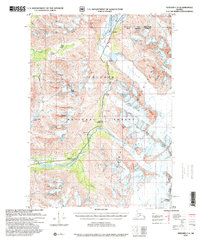
1997 Map of Seward C-6
USGS Topo · Published 2000About this map
The Kenai Mountains dominate this landscape, where high-altitude ice fields feed a network of glaciers including the Spencer Glacier and Bartlett Glacier. This late-1990s revision by the USDA Forest Service reveals the sparse human footprint within the Chugach National Forest, primarily clustered along the corridor formed by the Placer River and Trail Creek. Evidence of transportation and small-scale operations are visible at Grandview and the Tunnel railroad site, while localized activity is noted at the Pit near Hunter. The terrain is punctuated by significant summits like Tincan Peak and Anderson Peak, reflecting the area's role as a transition point between the Municipality of Anchorage and the Kenai Peninsula Borough. These labels capture a wilderness in the midst of shifting ice and seasonal recreation, exemplified by the curious naming of the Snoring Inn.
Find a feature on this map
31 named features on this map. Tap any name to fly to it.
Don’t see what you’re looking for? This feature index may not catch every label — zoom into the map to look around manually.
Map Details
Editions of this 1997 Seward C-6 Map
This is the sole edition of this map. No revisions or reprints were ever made.
Other maps of this area

1951 · Seward
USGS Topo · 1:250,000

1951 · Seward B-7
USGS Topo · 1:63,360

1951 · Seward C-6
USGS Topo · 1:63,360

1951 · Seward D-5
USGS Topo · 1:63,360

1951 · Seward C-5
USGS Topo · 1:63,360

1951 · Seward B-6
USGS Topo · 1:63,360

1951 · Seward B-5
USGS Topo · 1:63,360

1951 · Seward D-7
USGS Topo · 1:63,360

1951 · Seward C-7
USGS Topo · 1:63,360

1951 · Seward D-6
USGS Topo · 1:63,360