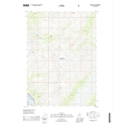
2017 Map of Seward D-6 NE
USGS Topo · Published 2017About this map
Chugach National Forest dominates this Alaskan landscape, where the high summits of the Chugach Mountains meet the waters of the Pacific Ocean. This 2017 survey details a wilderness primarily accessed by significant natural corridors and trail systems rather than dense settlement. The Seward Highway skirts the southwestern corner near the mouth of Peterson Cr, while the Inht: Upper Winner Creek Trail provides a passage through the interior high country. Significant peaks like Mt Alyeska and Hibbs Peak define the western elevations, giving way to the braided drainage systems of the Twentymile River and Glacier River in the east. The presence of Blueberry Hill and various named creeks like Winner Cr and Kern Cr suggests a landscape tied to both recreation and the natural resource boundaries of the Anchorage Municipality.
Find a feature on this map
21 named features on this map. Tap any name to fly to it.
Don’t see what you’re looking for? This feature index may not catch every label — zoom into the map to look around manually.
Map Details
Editions of this 2017 Seward D-6 NE Map
This is the sole edition of this map. No revisions or reprints were ever made.
Other maps of this area

1951 · Seward
USGS Topo · 1:250,000

1951 · Anchorage
USGS Topo · 1:250,000

1951 · Seward D-5
USGS Topo · 1:63,360

1951 · Seward D-6
USGS Topo · 1:63,360

1952 · Seward D-5
USGS Topo · 1:63,360

1952 · Seward D-6
USGS Topo · 1:63,360

1953 · Seward
USGS Topo · 1:250,000

1959 · Seward
USGS Topo · 1:250,000

1960 · Anchorage A-6
USGS Topo · 1:63,360

1960 · Anchorage A-5
USGS Topo · 1:63,360