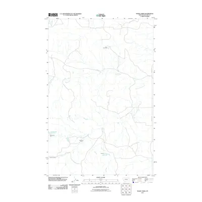
2011 Map of Shade Creek
USGS Topo · Published 2011About this map
Shade Creek and its many seasonal tributaries define the topography of this corner of McCone County, where water management is central to the landscape. This 2011 survey illustrates a sparse ranching and grazing environment marked by small-scale earthen works such as Taylor Shade Dam and Ruff Dam. The presence of these named dams and their associated catchments, including Christianson Reservoir and the uniquely named Torn Apart Dam, indicates a reliance on surface water storage in an otherwise arid drainage basin. Human presence is light, primarily concentrated along Prairie Elk Rd on the eastern edge of the quadrangle. The map captures the intricate drainage patterns of South Fork Shade Creek and Ruff Creek, revealing how modern land use persists through these vital water-holding features.
Find a feature on this map
11 named features on this map. Tap any name to fly to it.
Don’t see what you’re looking for? This feature index may not catch every label — zoom into the map to look around manually.
Map Details
Editions of this 2011 Shade Creek Map
This is the sole edition of this map. No revisions or reprints were ever made.
Other maps of this area

1954 · Jordan
USGS Topo · 1:250,000

1954 · Glendive
USGS Topo · 1:250,000

1956 · Jordan
USGS Topo · 1:250,000

1957 · Glendive
USGS Topo · 1:250,000

1958 · Jordan
USGS Topo · 1:250,000

1958 · Glendive
USGS Topo · 1:250,000

1964 · Jordan
USGS Topo · 1:250,000

1973 · Crow Springs
USGS Topo · 1:24,000
1973 · Willis Buttes
USGS Topo · 1:24,000
1973 · Pasture Creek
USGS Topo · 1:24,000