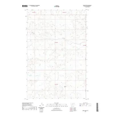
2020 Map of Shade Creek
USGS Topo · Published 2020About this map
Christianson Reservoir and the drainage of Shade Cr define this section of the high plains in McCone County. The landscape is characterized by a network of seasonal watercourses and deep-cut features like Williams Coulée, which suggest the challenges of ranching and navigation in this arid environment. Transportation is limited to a few established routes, primarily Shade Creek Rd and Prairie Elk Rd, which follow the natural contours of the land rather than a strict grid. The map details the complex system of coulees and creeks, including S Fork Shade Cr and Ruff Cr, that feed into the larger regional watershed. This 2020 survey documents the modern layout of the Public Land Survey System through T24N R45E and adjacent townships, marking out the vast, open acreage typical of eastern Montana’s ranching country.
Find a feature on this map
12 named features on this map. Tap any name to fly to it.
Don’t see what you’re looking for? This feature index may not catch every label — zoom into the map to look around manually.
Map Details
Editions of this 2020 Shade Creek Map
This is the sole edition of this map. No revisions or reprints were ever made.
Other maps of this area

1954 · Jordan
USGS Topo · 1:250,000

1954 · Glendive
USGS Topo · 1:250,000

1956 · Jordan
USGS Topo · 1:250,000

1957 · Glendive
USGS Topo · 1:250,000

1958 · Jordan
USGS Topo · 1:250,000

1958 · Glendive
USGS Topo · 1:250,000

1964 · Jordan
USGS Topo · 1:250,000

1973 · Crow Springs
USGS Topo · 1:24,000
1973 · Willis Buttes
USGS Topo · 1:24,000
1973 · Pasture Creek
USGS Topo · 1:24,000