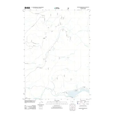
2012 Map of Shadow Mountain
USGS Topo · Published 2012About this map
Shadow Mountain rises as a central landmark in this Wyoming landscape, where high-altitude drainage systems feed into the Gros Ventre River. The map illustrates a transition from the rugged mountain slopes to the river valley, where the settlement of Kelly sits near the Kelly Warm Spring. This 2012 survey shows the modern footprint of institutional and recreational sites like the Teton Science School and Atherton Creek Campground, reflecting the area's role as a center for education and wilderness access. A complex network of watercourses, including Ditch Cr and its various forks, defines the terrain between Lost Creek Ranch and the southern river corridor. Roadways like Antelope Flats Rd and Gros Ventre Rd provide the primary access through this sparsely settled territory, which is marked by significant features like the Gros Ventre Overlook and Hardemann Reservoir.
Find a feature on this map
25 named features on this map. Tap any name to fly to it.
Don’t see what you’re looking for? This feature index may not catch every label — zoom into the map to look around manually.
Map Details
Editions of this 2012 Shadow Mountain Map
This is the sole edition of this map. No revisions or reprints were ever made.
Other maps of this area

1899 · Grand Teton
USGS Topo · 1:125,000

1901 · Grand Teton
USGS Topo · 1:125,000

1902 · Mt Leidy
USGS Topo · 1:125,000

1955 · Driggs
USGS Topo · 1:250,000

1958 · Driggs
USGS Topo · 1:250,000

1962 · Driggs
USGS Topo · 1:250,000

1965 · Davis Hill
USGS Topo · 1:24,000

1965 · Mount Leidy
USGS Topo · 1:24,000
1965 · Grizzly Lake
USGS Topo · 1:24,000

1968 · Moose
USGS Topo · 1:24,000