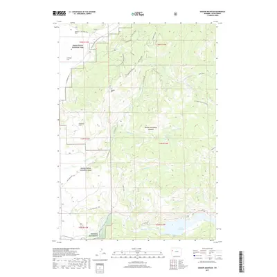
2017 Map of Shadow Mountain
USGS Topo · Published 2017About this map
Shadow Mtn stands as a central topographic anchor where the plains of Antelope Flats meet the higher timber of Teton National Forest. This 2017 study details a critical conservation and recreation landscape, showing the convergence of Grand Teton National Park and the northern reaches of the National Elk Refuge. The drainage patterns are defined by Ditch Cr and the Gros Ventre River, the latter feeding into Lower Slide Lake at the southern edge of the sheet. Local history is anchored by the Kelly Cem and the nearby Kelly Warm Spring, markers of early settlement and the unique geothermal character of the Jackson Hole region. A dense network of forest roads and loops, such as Shadow Loop and Ditch Creek Rd, illustrates the modern accessibility of these lands for public management.
Find a feature on this map
45 named features on this map. Tap any name to fly to it.
Don’t see what you’re looking for? This feature index may not catch every label — zoom into the map to look around manually.
Map Details
Editions of this 2017 Shadow Mountain Map
This is the sole edition of this map. No revisions or reprints were ever made.
Other maps of this area

1899 · Grand Teton
USGS Topo · 1:125,000

1901 · Grand Teton
USGS Topo · 1:125,000

1902 · Mt Leidy
USGS Topo · 1:125,000

1955 · Driggs
USGS Topo · 1:250,000

1958 · Driggs
USGS Topo · 1:250,000

1962 · Driggs
USGS Topo · 1:250,000

1965 · Davis Hill
USGS Topo · 1:24,000

1965 · Mount Leidy
USGS Topo · 1:24,000
1965 · Grizzly Lake
USGS Topo · 1:24,000

1968 · Moose
USGS Topo · 1:24,000