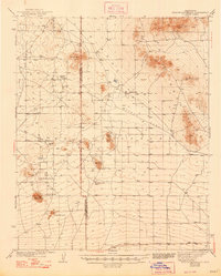
1942 Map of Shadow Mountains
USGS Topo · Published 1948About this map
Isolated homesteads and desert landmarks define this high-desert landscape along the Los Angeles Co San Bernardino Co line in the years leading up to the mid-century. The map captures a transition between the elevated terrain of the Shadow Mountains and the flat expanses of Mirage Lake and El Mirage Lake. Scattered across this arid environment are several established family sites, including Walton Place, Martin Ranch, and Vanderburg Ranch, which suggest a reliance on the numerous wells and tanks identified throughout the area.
Find a feature on this map
28 named features on this map. Tap any name to fly to it.
Don’t see what you’re looking for? This feature index may not catch every label — zoom into the map to look around manually.
Map Details
Editions of this 1942 Shadow Mountains Map
2 editions found

Other maps of this area

1901 · Southern California Sheet No. 1
USGS Topo · 1:250,000

1902 · Hesperia
USGS Topo · 1:62,500

1903 · Rock Creek
USGS Topo · 1:62,500

1903 · San Antonio
USGS Topo · 1:62,500

1904 · Southern California Sheet No. 1
USGS Topo · 1:250,000

1930 · Black Butte
USGS Topo · 1:24,000

1930 · El Mirage
USGS Topo · 1:24,000

1930 · Angle
USGS Topo · 1:24,000

1930 · Wilsona
USGS Topo · 1:24,000

1931 · Adobe
USGS Topo · 1:24,000