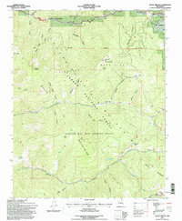
1995 Map of Shady Brook
USGS Topo · Published 1997About this map
Shady Brook and the mountain community of Valle Escondido sit within the high-elevation terrain of the Sangre de Cristo Mountains during the mid-1990s. The landscape is defined by the complex geography of the Rancho del Rio Grande Grant, where the Taos and Mora county boundary lines intersect steep canyons and timbered ridges. Hydrological patterns are dictated by the Rio Fernando de Taos and Rio Chiquito, which drain various named canyons such as Suazo Canyon and Buena Suerte Canyon. Within the Carson National Forest, specific recreational and local landmarks like Garcia Park and Paradise Park are identified alongside high points like the Sierra de Don Fernando. The inclusion of a small Cemetery and multiple springs, including Porky Spring and Ryan Spring, provides valuable detail for those tracing the historical settlement and land-use patterns of these northern New Mexico grants.
Find a feature on this map
46 named features on this map. Tap any name to fly to it.
Don’t see what you’re looking for? This feature index may not catch every label — zoom into the map to look around manually.
Map Details
Editions of this 1995 Shady Brook Map
This is the sole edition of this map. No revisions or reprints were ever made.
Other maps of this area

1954 · Raton
USGS Topo · 1:250,000

1958 · Raton
USGS Topo · 1:250,000

1964 · Taos
USGS Topo · 1:24,000

1964 · Tres Ritos
USGS Topo · 1:24,000

1964 · Ranchos De Taos
USGS Topo · 1:24,000

1965 · Osha Mountain
USGS Topo · 1:24,000

1965 · Chacon
USGS Topo · 1:24,000

1965 · Palo Flechado Pass
USGS Topo · 1:24,000

1965 · Pueblo Peak
USGS Topo · 1:24,000

1965 · Shady Brook
USGS Topo · 1:24,000