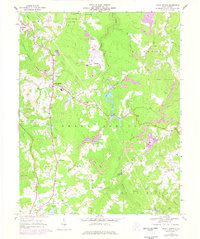
1968 Map of Shady Spring
USGS Topo · Published 1977About this map
Shady Spring Mtn and Rich Mountain dominate this corner of West Virginia, where the West Virginia Turnpike cuts a path through the high ridges. The landscape in the late 1960s shows a complex mix of recreation and industry, with the developed waters of Flat Top Lake and Little Beaver Lake countered by numerous strip mines scarring the northern slopes of Rich Mountain.
Find a feature on this map
54 named features on this map. Tap any name to fly to it.
Don’t see what you’re looking for? This feature index may not catch every label — zoom into the map to look around manually.
Map Details
Editions of this 1968 Shady Spring Map
2 editions found
Other maps of this area

1887 · Hinton
USGS Topo · 1:125,000

1891 · Raleigh
USGS Topo · 1:125,000

1892 · Hinton
USGS Topo · 1:125,000

1897 · Raleigh
USGS Topo · 1:125,000

1902 · Raleigh
USGS Topo · 1:125,000

1911 · Flattop
USGS Topo · 1:48,000

1911 · Beckley
USGS Topo · 1:48,000

1912 · Meadow Creek
USGS Topo · 1:48,000

1912 · Big Bend
USGS Topo · 1:62,500

1913 · Beckley
USGS Topo · 1:62,500