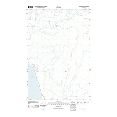
2011 Map of Shale Slough
USGS Topo · Published 2011About this map
The Quinault River dominates this coastal landscape as it flows toward the Pacific Ocean, cutting through a network of creeks and prairie land. This 2011 survey illustrates the complex hydrology of the region, where the main river channel is joined by Shale Slough and various tributaries including Mounts Creek and Railroad Creek. The Chow Chow Bridge serves as a critical crossing point in a territory otherwise defined by its water systems and Bureau of Indian Affairs (BIA) access roads. Further south, the terrain transitions into the drainage basins of the Wreck Creek and the North Fork Moclips River. This map is particularly valuable for its depiction of Baker Prairie, a distinct geographical opening within the heavily forested coastal corridor, and the dense web of forest roads like Bia 7000 RD that navigate the timbered slopes.
Find a feature on this map
37 named features on this map. Tap any name to fly to it.
Don’t see what you’re looking for? This feature index may not catch every label — zoom into the map to look around manually.
Map Details
Editions of this 2011 Shale Slough Map
This is the sole edition of this map. No revisions or reprints were ever made.
Other maps of this area

1938 · Moclips
USGS Topo · 1:62,500

1941 · Moclips
USGS Topo · 1:62,500

1943 · Copalis Beach
USGS Topo · 1:250,000

1951 · Copalis Beach
USGS Topo · 1:250,000

1955 · Taholah
USGS Topo · 1:62,500

1955 · Macafee Hill
USGS Topo · 1:62,500

1955 · Carlisle
USGS Topo · 1:24,000
1955 · Moclips
USGS Topo · 1:24,000

1957 · Copalis Beach
USGS Topo · 1:250,000

1963 · Copalis Beach
USGS Topo · 1:250,000