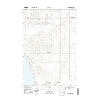
2014 Map of Shale Slough
USGS Topo · Published 2014About this map
Qui-nai-elt Village and the coastal settlement of Taholah anchor this 2014 study of the Olympic Peninsula's southwestern edge, where the Quinault River meets the Pacific Ocean. The landscape is defined by a dense network of Bureau of Indian Affairs (BIA) routes, including BIA 7615 Rd and BIA 7505 Rd, which weave through the timberlands and cross the river at the Chow Chow Bridge. South of the river's delta, the terrain shifts into the open spaces of Baker Prairie, drained by the winding courses of Wreck Cr and the North Fork Moclips River. This survey captures the modern infrastructure within the Quinault Indian Reservation, documenting the intricate hydrology of Shale Slough and the numerous small creeks like Duck Cr and Canyon Cr that carve through the coastal forest.
Find a feature on this map
40 named features on this map. Tap any name to fly to it.
Don’t see what you’re looking for? This feature index may not catch every label — zoom into the map to look around manually.
Map Details
Editions of this 2014 Shale Slough Map
This is the sole edition of this map. No revisions or reprints were ever made.
Other maps of this area

1938 · Moclips
USGS Topo · 1:62,500

1941 · Moclips
USGS Topo · 1:62,500

1943 · Copalis Beach
USGS Topo · 1:250,000

1951 · Copalis Beach
USGS Topo · 1:250,000

1955 · Taholah
USGS Topo · 1:62,500

1955 · Macafee Hill
USGS Topo · 1:62,500

1955 · Carlisle
USGS Topo · 1:24,000
1955 · Moclips
USGS Topo · 1:24,000

1957 · Copalis Beach
USGS Topo · 1:250,000

1963 · Copalis Beach
USGS Topo · 1:250,000