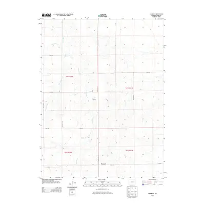
2013 Map of Shamrock
USGS Topo · Published 2013About this map
Shamrock sits at the southern edge of this high plains landscape, where the agricultural grid meets a series of intermittent watercourses. The drainage of Sand Arroyo Cr and its tributaries, including W Fork San Arroyo Cr and Hoffman Cr, cut through the terrain, defining the local topography. This early 21st-century survey documents a sparsely populated rural district where large-scale land divisions are marked by a naming convention of numbered avenues and idiosyncratic road names.
Find a feature on this map
22 named features on this map. Tap any name to fly to it.
Don’t see what you’re looking for? This feature index may not catch every label — zoom into the map to look around manually.
Map Details
Editions of this 2013 Shamrock Map
This is the sole edition of this map. No revisions or reprints were ever made.
Other maps of this area

1954 · Limon
USGS Topo · 1:250,000

1954 · Sterling
USGS Topo · 1:250,000

1957 · Limon
USGS Topo · 1:250,000

1958 · Limon
USGS Topo · 1:250,000

1958 · Sterling
USGS Topo · 1:250,000

1963 · Adena
USGS Topo · 1:24,000

1965 · Vallery SE
USGS Topo · 1:24,000

1965 · Huey Ranch
USGS Topo · 1:24,000
1973 · Potty Brown Creek
USGS Topo · 1:24,000

1973 · Shamrock
USGS Topo · 1:24,000