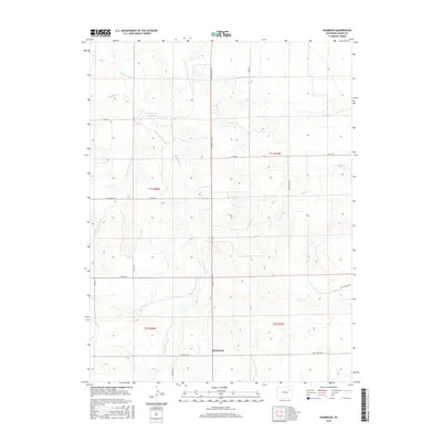
2016 Map of Shamrock
USGS Topo · Published 2016About this map
Shamrock sits at the intersection of East 104th Ave and Shamrock Mile Rd, surrounded by a landscape of intermittent watercourses in eastern Colorado. The terrain is defined by the drainage patterns of Sand Arroyo Cr and the West Fork San Arroyo Cr, which wind through the township grids. Agricultural and ranching infrastructure is evident in the presence of Simpsons Reservoir and the network of section-line roads like Co Rd 64 and 144th Ave. Smaller tributaries such as Hoffman Cr carve into the high plains, illustrating the water management necessary for this region. This 2016 survey provides a clear view of the modern rural layout, including local markers like Pay Rock Rd and Paperbirch Rd.
Find a feature on this map
22 named features on this map. Tap any name to fly to it.
Don’t see what you’re looking for? This feature index may not catch every label — zoom into the map to look around manually.
Map Details
Editions of this 2016 Shamrock Map
This is the sole edition of this map. No revisions or reprints were ever made.
Other maps of this area

1954 · Limon
USGS Topo · 1:250,000

1954 · Sterling
USGS Topo · 1:250,000

1957 · Limon
USGS Topo · 1:250,000

1958 · Limon
USGS Topo · 1:250,000

1958 · Sterling
USGS Topo · 1:250,000

1963 · Adena
USGS Topo · 1:24,000

1965 · Vallery SE
USGS Topo · 1:24,000

1965 · Huey Ranch
USGS Topo · 1:24,000
1973 · Potty Brown Creek
USGS Topo · 1:24,000

1973 · Shamrock
USGS Topo · 1:24,000