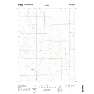
2019 Map of Shamrock
USGS Topo · Published 2019About this map
Shamrock sits at a remote crossroads in eastern Adams County, where the high plains are defined by a network of seasonal watercourses. The local hydrology is dominated by Sand Arroyo Creek and its various branches, including the W Fork Sand Arroyo Cr and Sand Arroyo Cr. These ephemeral streams carve through the landscape, creating a pattern of drainage that flows toward Simpsons Reservoir, a significant water feature for this arid region. The road network follows a strict sectional grid typical of the American West, with thoroughfares like Shamrock Mile Rd and Pay Rock Rd providing access to the sprawling agricultural tracts. Smaller tributaries such as Hoffman Cr further illustrate the intricate watershed that supports the life and economy of this rural Colorado community.
Find a feature on this map
22 named features on this map. Tap any name to fly to it.
Don’t see what you’re looking for? This feature index may not catch every label — zoom into the map to look around manually.
Map Details
Editions of this 2019 Shamrock Map
This is the sole edition of this map. No revisions or reprints were ever made.
Other maps of this area

1954 · Limon
USGS Topo · 1:250,000

1954 · Sterling
USGS Topo · 1:250,000

1957 · Limon
USGS Topo · 1:250,000

1958 · Limon
USGS Topo · 1:250,000

1958 · Sterling
USGS Topo · 1:250,000

1963 · Adena
USGS Topo · 1:24,000

1965 · Vallery SE
USGS Topo · 1:24,000

1965 · Huey Ranch
USGS Topo · 1:24,000
1973 · Potty Brown Creek
USGS Topo · 1:24,000

1973 · Shamrock
USGS Topo · 1:24,000