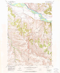
1956 Map of Shane Ridge
USGS Topo · Published 1974About this map
Yellowstone River dominates the northern reaches of this mid-century landscape, where the Northern Pacific railroad tracks parallel the water's edge. The terrain transitions from the broad Flaherty Flat and the prominent Countrymans Bluff into the high, dissected country of Shane Ridge. Settlement patterns of the 1950s are evidenced by several rural schoolhouses scattered across the high ground, including Standard Sch and Tutt Creek Sch.
Find a feature on this map
23 named features on this map. Tap any name to fly to it.
Don’t see what you’re looking for? This feature index may not catch every label — zoom into the map to look around manually.
Map Details
Editions of this 1956 Shane Ridge Map
2 editions found
Other maps of this area

1892 · Stillwater
USGS Topo · 1:125,000

1932 · Red Lodge No 2
USGS Topo · 1:48,000

1932 · Red Lodge No 1
USGS Topo · 1:48,000

1954 · Billings
USGS Topo · 1:250,000

1955 · Whitebird School
USGS Topo · 1:24,000

1956 · Columbus West
USGS Topo · 1:24,000

1956 · Shane Ridge
USGS Topo · 1:24,000

1956 · Horse Butte
USGS Topo · 1:24,000

1956 · Columbus East
USGS Topo · 1:24,000

1956 · Roscoe NE
USGS Topo · 1:24,000