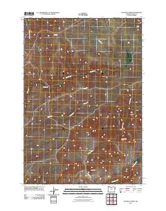
2011 Map of Shaniko Summit
USGS Topo · Published 2011About this map
Shaniko Summit stands as the central landmark in this high-elevation landscape of North Central Oregon, situated where Wasco County meets its southern neighbors. The terrain is defined by a dendritic network of seasonal drainages, including Cottonwood Creek, Ward Creek, and Boat Creek, which carve through the plateau. Human imprint is sparse, concentrated primarily at the Rooper Ranch and along the winding corridor of Rooper Rd. Notable geographic features such as Courthouse Rock and Cross Hill provide distinct navigational points in an otherwise open expanse. To the southeast, Antelope Creek flows toward the lower elevations, while Cross Hollows marks the northeastern corner. This 2011 survey captures the region's enduring character as a ranching landscape, where traditional land use and natural topography remain the primary features of the map.
Find a feature on this map
11 named features on this map. Tap any name to fly to it.
Don’t see what you’re looking for? This feature index may not catch every label — zoom into the map to look around manually.
Map Details
Editions of this 2011 Shaniko Summit Map
This is the sole edition of this map. No revisions or reprints were ever made.
Other maps of this area

1953 · The Dalles
USGS Topo · 1:250,000

1955 · Bend
USGS Topo · 1:250,000

1956 · The Dalles
USGS Topo · 1:250,000

1957 · Bend
USGS Topo · 1:250,000

1957 · The Dalles
USGS Topo · 1:250,000

1958 · Bend
USGS Topo · 1:250,000

1966 · Antelope
USGS Topo · 1:62,500

1966 · Willowdale
USGS Topo · 1:62,500

1970 · Macken Canyon
USGS Topo · 1:24,000
1971 · Criterion
USGS Topo · 1:24,000