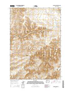
2014 Map of Shaniko Summit
USGS Topo · Published 2014About this map
Shaniko sits at the edge of this high plateau country where the high desert meets the canyonlands of north-central Oregon. The landscape is defined by its dramatic verticality, as the terrain drops from the eponymous Shaniko Summit into a complex network of seasonal drainages including Mary McKinley Draw and Deep Canyon. The topographic detail reveals the intricate erosion patterns of the region, highlighting landmarks like Courthouse Rock and the steep descents into Deadman Canyon and Chain Canyon. This modern survey records the enduring ranching and transportation corridors of Wasco County, with Us-97 and Or-293 following the natural contours of the land. These roads connect the small settlement of Shaniko to the broader region, navigating between prominent rises such as Cross Hill and the winding paths of Cottonwood Cr and Ward Cr.
Find a feature on this map
23 named features on this map. Tap any name to fly to it.
Don’t see what you’re looking for? This feature index may not catch every label — zoom into the map to look around manually.
Map Details
Editions of this 2014 Shaniko Summit Map
This is the sole edition of this map. No revisions or reprints were ever made.
Other maps of this area

1953 · The Dalles
USGS Topo · 1:250,000

1955 · Bend
USGS Topo · 1:250,000

1956 · The Dalles
USGS Topo · 1:250,000

1957 · Bend
USGS Topo · 1:250,000

1957 · The Dalles
USGS Topo · 1:250,000

1958 · Bend
USGS Topo · 1:250,000

1966 · Antelope
USGS Topo · 1:62,500

1966 · Willowdale
USGS Topo · 1:62,500

1970 · Macken Canyon
USGS Topo · 1:24,000
1971 · Criterion
USGS Topo · 1:24,000