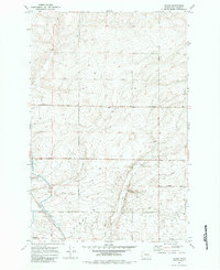
1970 Map of Shano
USGS Topo · Published 1984About this map
Paradise Flats defines the central topography of this section of Adams County, where the agricultural landscape meets the vital water infrastructure of the Columbia Basin Project. The small settlement of Shano serves as a localized hub for the rail-and-water economy, situated along the Burlington Northern line. The presence of Grain Elevators at this site underscores the region's reliance on dryland and irrigated farming, facilitated by the engineering of the East Low Canal and the nearby Shano Siphon.
Find a feature on this map
23 named features on this map. Tap any name to fly to it.
Don’t see what you’re looking for? This feature index may not catch every label — zoom into the map to look around manually.
Map Details
Editions of this 1970 Shano Map
2 editions found
Other maps of this area

1916 · Connell
USGS Topo · 1:125,000

1918 · Connell
USGS Topo · 1:125,000

1924 · Othello
USGS Topo · 1:62,500

1925 · Scooteney Lake
USGS Topo · 1:62,500

1951 · Scooteney Lake
USGS Topo · 1:62,500

1953 · Walla Walla
USGS Topo · 1:250,000

1954 · Bruce
USGS Topo · 1:24,000

1954 · Warden
USGS Topo · 1:24,000

1954 · Othello
USGS Topo · 1:62,500

1958 · Walla Walla
USGS Topo · 1:250,000