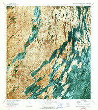
1972 Map of Shark Valley Lookout Tower
USGS Topo · Published 1990About this map
Everglades National Park dominates this 1970s orthophotomap, revealing the intricate water-and-land patterns of the Florida interior. The unique photographic base layer distinguishes this sheet from traditional line-and-tint maps, providing a literal view of the vegetation and hydrology at the border of Monroe and Dade counties. The Shark Valley Slough and East Slough move through the landscape, surrounding isolated tree islands such as Dogwood Hammock, Iron Pot Hammock, and Seagrape Hammock. Human activity is marked by the presence of the Shark Valley Lookout Tower and a remote Landing Strip in the southwest. Transport through this wetland environment is defined by an Airboat Trail and Trail segments that navigate the transition between the sloughs and elevations like Rattlesnake Ridge.
Find a feature on this map
12 named features on this map. Tap any name to fly to it.
Don’t see what you’re looking for? This feature index may not catch every label — zoom into the map to look around manually.
Map Details
Editions of this 1972 Shark Valley Lookout Tower Map
2 editions found
Other maps of this area

1956 · Miami
USGS Topo · 1:250,000

1958 · Miami
USGS Topo · 1:250,000

1972 · Shark Valley Lookout Tower
USGS Topo · 1:24,000

1972 · Lostmans Trail
USGS Topo · 1:24,000

1972 · Chekika Island
USGS Topo · 1:24,000

1972 · Panther Mound
USGS Topo · 1:24,000

1972 · Indian Camp Creek
USGS Topo · 1:24,000
1972 · Black Hammock
USGS Topo · 1:24,000

1973 · Fortymile Bend
USGS Topo · 1:24,000

1973 · Fiftymile Bend
USGS Topo · 1:24,000