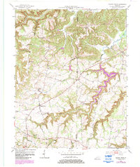
1952 Map of Sharon Grove
USGS Topo · Published 1984About this map
The boundary between Todd Co and Logan Co defines the social and topographical landscape of this mid-century survey. Settlement patterns favor the higher elevations and ridge lines, notably at Duncan Ridge, where the Duncan Ridge Sch served the surrounding farmsteads. The area is dense with community landmarks that reflect the era's local rural organization, including schools like Hickory Ridge Sch and Mineral Spring Sch, alongside numerous country churches such as Mt Vernon Ch and Pleasant Hill Ch.
Find a feature on this map
30 named features on this map. Tap any name to fly to it.
Don’t see what you’re looking for? This feature index may not catch every label — zoom into the map to look around manually.
Map Details
Editions of this 1952 Sharon Grove Map
Other maps of this area

1911 · Drakesboro
USGS Topo · 1:48,000

1911 · Dunmor
USGS Topo · 1:48,000

1913 · Drakesboro
USGS Topo · 1:62,500

1914 · Dunmor
USGS Topo · 1:62,500

1950 · Olmstead
USGS Topo · 1:24,000

1951 · Elkton
USGS Topo · 1:24,000

1951 · Olmstead
USGS Topo · 1:24,000

1951 · Lewisburg
USGS Topo · 1:24,000

1952 · Russellville
USGS Topo · 1:24,000

1952 · Sharon Grove
USGS Topo · 1:24,000