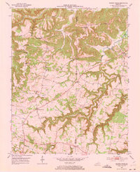
1952 Map of Sharon Grove
USGS Topo · Published 1973About this map
Sharon Grove and the surrounding farming communities of south-central Kentucky are captured in this 1952 study, revealing a landscape defined by small-scale rural infrastructure and winding watercourses. The territory is marked by numerous country churches and schools that once served as the social anchors for local families, including the Mineral Spring Ch, Antioch Ch, and the Hickory Ridge Sch. The winding Wolf Lick Creek and Whippoorwill Creek cut through the terrain, while the boundary between Todd and Logan counties bisects the map, passing near the settlement of Everett. Genealogists will find particular value in the documentation of family-named landmarks like the Gant Cem and the Tunstill Cem, providing a precise record of local burial sites and landholdings before late-century consolidation altered the rural fabric of the region.
Find a feature on this map
28 named features on this map. Tap any name to fly to it.
Don’t see what you’re looking for? This feature index may not catch every label — zoom into the map to look around manually.
Map Details
Editions of this 1952 Sharon Grove Map
Other maps of this area

1911 · Drakesboro
USGS Topo · 1:48,000

1911 · Dunmor
USGS Topo · 1:48,000

1913 · Drakesboro
USGS Topo · 1:62,500

1914 · Dunmor
USGS Topo · 1:62,500

1950 · Olmstead
USGS Topo · 1:24,000

1951 · Elkton
USGS Topo · 1:24,000

1951 · Olmstead
USGS Topo · 1:24,000

1951 · Lewisburg
USGS Topo · 1:24,000

1952 · Russellville
USGS Topo · 1:24,000

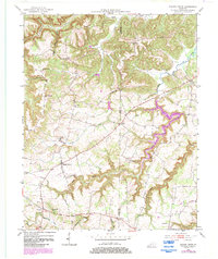
1952 · Sharon Grove
USGS Topo · 1:24,000