
1960 Map of Sharon
USGS Topo · Published 1961About this map
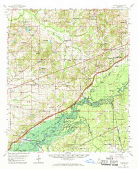
The Pearl River dominates the southern landscape of this 1960 survey, a moment of significant transition as the Pearl River Valley Reservoir project prepared to submerge extensive bottomlands. The map clearly identifies the future shoreline and area to be inundated, affecting numerous sloughs and lakes such as Blue Lake and Horseshoe Lake. Beyond the river valley, the terrain is dotted with small rural communities like Sharon and Farmhaven, characterized by a high density of country churches and schools, including Sacred Heart Mission, St John Ch, and the Sand Hill Sch. The historic Natchez Trace Parkway cuts across the center, intersecting an older network of routes and the Illinois Central Railroad corridor. This era captures the traditional settlement patterns of Madison County just before the reservoir's creation permanently altered the local geography and land use.
Find a feature on this map
109 named features on this map. Tap any name to fly to it.
Don’t see what you’re looking for? This feature index may not catch every label — zoom into the map to look around manually.
Map Details
Editions of this 1960 Sharon Map
2 editions found
Other maps of this area

1903 · Jackson
USGS Topo · 1:125,000

1905 · Jackson
USGS Topo · 1:48,000

1908 · Jackson
USGS Topo · 1:62,500

1922 · Morton
USGS Topo · 1:48,000

1922 · Pelahatchee
USGS Topo · 1:48,000

1924 · Pelahatchee
USGS Topo · 1:62,500

1924 · Morton
USGS Topo · 1:62,500

1950 · Pelahatchie
USGS Topo · 1:62,500

1951 · Morton
USGS Topo · 1:62,500

1952 · Pelahatchie
USGS Topo · 1:62,500