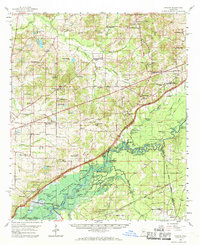
1960 Map of Sharon
USGS Topo · Published 1970About this map
Natchez Trace Parkway cuts diagonally across this 1960s landscape, intersecting a dense network of rural communities such as Sharon, Farmhaven, and Shoccoe. This survey captures the Madison and Rankin County line just before the filling of the Pearl River Reservoir, with large swaths of the southern bottomlands shown as planned for submergence. The topographic detail reveals a landscape defined by its spiritual and educational hubs, including the Sacred Heart Mission, Immaculate Conception Ch, and numerous segregated local institutions like the Rising Star Sch and Pleasant Gift Sch.
Find a feature on this map
107 named features on this map. Tap any name to fly to it.
Don’t see what you’re looking for? This feature index may not catch every label — zoom into the map to look around manually.
Map Details
Editions of this 1960 Sharon Map
2 editions found

Other maps of this area

1903 · Jackson
USGS Topo · 1:125,000

1905 · Jackson
USGS Topo · 1:48,000

1908 · Jackson
USGS Topo · 1:62,500

1922 · Morton
USGS Topo · 1:48,000

1922 · Pelahatchee
USGS Topo · 1:48,000

1924 · Pelahatchee
USGS Topo · 1:62,500

1924 · Morton
USGS Topo · 1:62,500

1950 · Pelahatchie
USGS Topo · 1:62,500

1951 · Morton
USGS Topo · 1:62,500

1952 · Pelahatchie
USGS Topo · 1:62,500