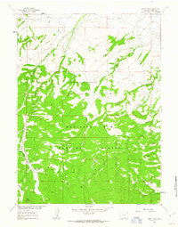
1961 Map of Sharp Hill
USGS Topo · Published 1963About this map
Medicine Bow National Forest dominates this section of Carbon County, where high-elevation drainage patterns define the landscape of the early 1960s. The map illustrates a managed wilderness where early infrastructure supports both resource extraction and conservation, evidenced by the central presence of the Jack Creek Guard Sta and a nearby Mine. Water management is a primary feature of the terrain, as seen in the Jack Creek Ditch and the convergence of numerous named streams including Buck Methodist Creek, Alameda Creek, and Cherokee Creek. The prominence of the Jack Creek Campground suggests the area's established role in public recreation during this era. A network of primitive transit is marked by a Jeep Trail, which winds through the southern elevations toward the distinctive peak of Sharp Hill.
Find a feature on this map
17 named features on this map. Tap any name to fly to it.
Don’t see what you’re looking for? This feature index may not catch every label — zoom into the map to look around manually.
Map Details
Editions of this 1961 Sharp Hill Map
4 editions found
Other maps of this area

1932 · Savery
USGS Topo · 1:96,000

1939 · Saratoga
USGS Topo · 1:125,000

1940 · Savery
USGS Topo · 1:125,000

1954 · Rawlins
USGS Topo · 1:250,000

1958 · Rawlins
USGS Topo · 1:250,000

1961 · Red Mountain
USGS Topo · 1:24,000

1961 · Divide Peak
USGS Topo · 1:24,000

1961 · Middlewood Hill
USGS Topo · 1:24,000

1961 · Bridger Peak
USGS Topo · 1:24,000

1961 · Jack Creek Reservoir
USGS Topo · 1:24,000