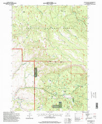
1995 Map of Sharp Ridge
USGS Topo · Published 1998About this map
Sharp Ridge defines the high divide between the Umatilla National Forest and Malheur National Forest in this mid-1990s survey. The landscape is characterized by a dense network of mountain springs and high-elevation meadows, such as Pizer Meadow and Howard Meadow, which have long served as significant landmarks for forest navigation. Resource extraction is evident through scattered sites like Keenley Mine and several unnamed quarries, pointing to the region's history of small-scale mining and road building.
Find a feature on this map
44 named features on this map. Tap any name to fly to it.
Don’t see what you’re looking for? This feature index may not catch every label — zoom into the map to look around manually.
Map Details
Editions of this 1995 Sharp Ridge Map
This is the sole edition of this map. No revisions or reprints were ever made.
Other maps of this area

1949 · Susanville
USGS Topo · 1:62,500

1951 · Susanville
USGS Topo · 1:62,500

1951 · Dale
USGS Topo · 1:62,500

1951 · Bates
USGS Topo · 1:62,500

1951 · Desolation Butte
USGS Topo · 1:62,500

1955 · Canyon City
USGS Topo · 1:250,000

1959 · Canyon City
USGS Topo · 1:250,000
1987 · Bates
USGS Topo · 1:100,000
1988 · Desolation Butte
USGS Topo · 1:24,000
1988 · Kelsay Butte
USGS Topo · 1:24,000