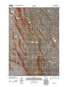
2011 Map of Sharp Top
USGS Topo · Published 2011About this map
Sharp Top dominates the landscape of this high desert portion of Lake County, where survival and movement are defined by a network of seasonal water sources. The map reveals a reliance on isolated waterholes scattered across the arid terrain, ranging from Inter Mountain Waterhole in the north to Little Waterhole in the southeast. These features, along with names like Wildcat Waterhole and Giant Waterhole, suggest a long history of cattle ranching or wildlife management in a region where surface water is scarce. Human infrastructure is limited to sparse corridors such as Sand Hollow Rd and County Rd 8-14A, which trace the low-lying Sand Hollow. In the east, Twin Lakes provides a rare natural landmark in an otherwise open and windswept expanse of the Oregon high country.
Find a feature on this map
15 named features on this map. Tap any name to fly to it.
Don’t see what you’re looking for? This feature index may not catch every label — zoom into the map to look around manually.
Map Details
Editions of this 2011 Sharp Top Map
This is the sole edition of this map. No revisions or reprints were ever made.
Other maps of this area

1955 · Klamath Falls
USGS Topo · 1:250,000

1958 · Klamath Falls
USGS Topo · 1:250,000

1966 · Coglan Buttes NE
USGS Topo · 1:24,000

1966 · Coglan Buttes
USGS Topo · 1:24,000

1966 · Paisley
USGS Topo · 1:24,000

1974 · Lake Abert
USGS Topo · 1:100,000

1985 · Sharp Top
USGS Topo · 1:24,000
1985 · Biscuit Point
USGS Topo · 1:24,000
1985 · Diatomite Reservoir
USGS Topo · 1:24,000
1986 · Loco Lake
USGS Topo · 1:24,000