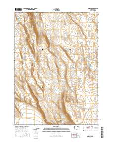
2014 Map of Sharp Top
USGS Topo · Published 2014About this map
Diablo Rim and Sharp Top anchor a high-elevation landscape in Lake County defined by strategic water management. This high-desert terrain is characterized by a sophisticated network of catchments, including the Giant Waterhole, Yankee Waterhole, and Between Rim Waterhole. These features reflect the area's history of livestock ranching and resource conservation in a land where water is the primary currency. The presence of Whiskey Mtn and the long depression of Sand Hollow further illustrate the topographic challenges faced by early land users. Evidence of infrastructure is sparse, primarily confined to Co Road 6144, which facilitates movement between the volcanic uplands of Coglan Butte and the scattered ephemeral basins of Twin Lakes.
Find a feature on this map
21 named features on this map. Tap any name to fly to it.
Don’t see what you’re looking for? This feature index may not catch every label — zoom into the map to look around manually.
Map Details
Editions of this 2014 Sharp Top Map
This is the sole edition of this map. No revisions or reprints were ever made.
Other maps of this area

1955 · Klamath Falls
USGS Topo · 1:250,000

1958 · Klamath Falls
USGS Topo · 1:250,000

1966 · Coglan Buttes NE
USGS Topo · 1:24,000

1966 · Coglan Buttes
USGS Topo · 1:24,000

1966 · Paisley
USGS Topo · 1:24,000

1974 · Lake Abert
USGS Topo · 1:100,000

1985 · Sharp Top
USGS Topo · 1:24,000
1985 · Biscuit Point
USGS Topo · 1:24,000
1985 · Diatomite Reservoir
USGS Topo · 1:24,000
1986 · Loco Lake
USGS Topo · 1:24,000