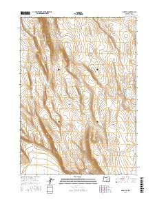
2017 Map of Sharp Top
USGS Topo · Published 2017About this map
Sharp Top stands as the central topographic landmark in this high-desert portion of Lake County, Oregon. The landscape is defined by its arid-land water management, featuring a dispersed network of vital sources such as Inter Mountain Waterhole, Wildcat Waterhole, and Giant Waterhole. These features, along with Twin Lakes to the east, trace the precarious balance of ranching and survival in the Oregon outback. The northern edge of the map is dominated by the steep ascent of Diablo Rim, while the southern reaches descend into Sand Hollow. Roads are sparse, represented primarily by Co Rd 6144 and Lake Co Rd 2-06, reflecting the isolation of the high plateau and the specialized infrastructure required for livestock across the sprawling township and range lines.
Find a feature on this map
16 named features on this map. Tap any name to fly to it.
Don’t see what you’re looking for? This feature index may not catch every label — zoom into the map to look around manually.
Map Details
Editions of this 2017 Sharp Top Map
This is the sole edition of this map. No revisions or reprints were ever made.
Other maps of this area

1955 · Klamath Falls
USGS Topo · 1:250,000

1958 · Klamath Falls
USGS Topo · 1:250,000

1966 · Coglan Buttes NE
USGS Topo · 1:24,000

1966 · Coglan Buttes
USGS Topo · 1:24,000

1966 · Paisley
USGS Topo · 1:24,000

1974 · Lake Abert
USGS Topo · 1:100,000

1985 · Sharp Top
USGS Topo · 1:24,000
1985 · Biscuit Point
USGS Topo · 1:24,000
1985 · Diatomite Reservoir
USGS Topo · 1:24,000
1986 · Loco Lake
USGS Topo · 1:24,000