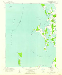
1942 Map of Sharps Island
USGS Topo · Published 1961About this map
Hills Point Neck and the surrounding Chesapeake estuaries are captured here as they appeared during the early 1940s, a landscape defined by its intricate shoreline and maritime reliance. Small shoreline communities like Thomas, Hudson, and James are connected by narrow roads, with the Hudson Sch serving the local families of this low-lying peninsula. The survey illustrates the vulnerability of this coast, depicting the shrinking footprint of Sharps Island and James Island at a time before significant modern erosion further altered these landmasses. Navigational markers, including a Light in the Little Choptank River, highlight the importance of the waterways for local commerce. Between Brooks Creek and Cassen Neck, the map reveals a pattern of scattered farmsteads and tidal marshes, offering a precise view of Dorchester County's historical geography.
Find a feature on this map
32 named features on this map. Tap any name to fly to it.
Don’t see what you’re looking for? This feature index may not catch every label — zoom into the map to look around manually.
Map Details
Editions of this 1942 Sharps Island Map
This is the sole edition of this map. No revisions or reprints were ever made.
Other maps of this area

1892 · Drum Point
USGS Topo · 1:62,500

1893 · Sharps Island
USGS Topo · 1:62,500

1898 · Choptank
USGS Topo · 1:125,000

1898 · St. Marys
USGS Topo · 1:125,000

1901 · Drum Point
USGS Topo · 1:62,500

1904 · Sharps Island
USGS Topo · 1:62,500

1904 · Oxford
USGS Topo · 1:62,500

1905 · Crapo
USGS Topo · 1:62,500

1905 · Drum Point
USGS Topo · 1:62,500

1906 · St. Marys
USGS Topo · 1:125,000